
Transformative Impact of Laser Scanning Services in Construction and Design
3D Building Scan & Revit Modelling NZ
This case study explores how a forward-thinking team of architects embraced laser scan services to revolutionise data capture in construction and design projects.
The objective was to assess the impact of this technology on improving design decisions and project management practices, reflecting the ongoing quest for innovation in the industry.
Design leads, AND Architecture, sought not only to enjoy the rapid delivery of measured data from laser scan services but also to benefit from the long-term improvements on project timelines, costs and overall outcomes.
Shaun Anderson of AND Architects comments “having the 3D Scan allowed is to quickly transpose the ‘real world’ to a virtual model. Having a digitised model of the building, surrounding site, and services allowed us to quickly develop and provide iterations throughout the design process.
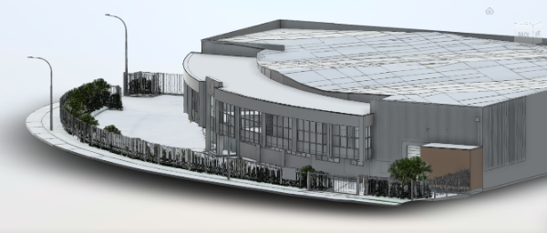
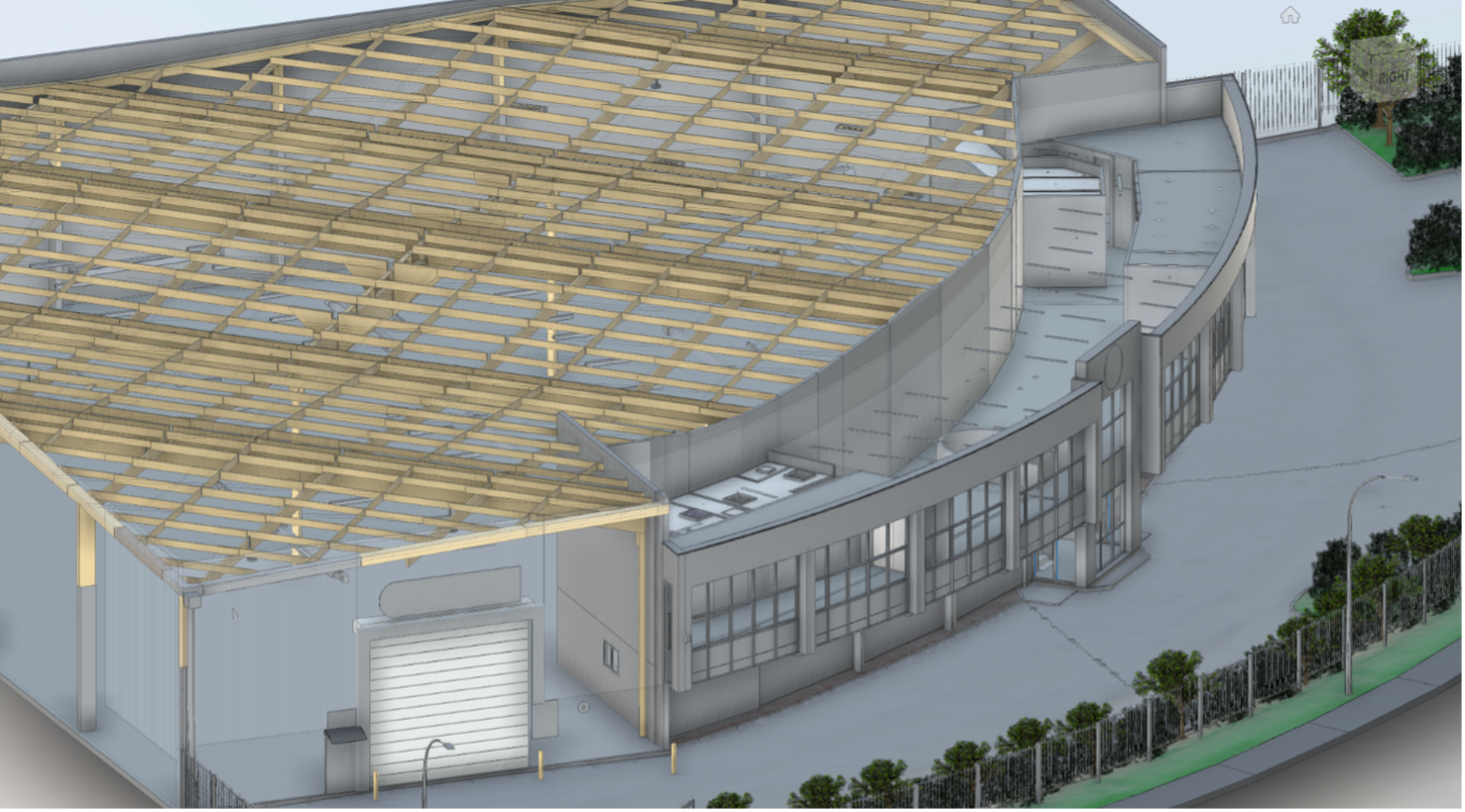
Recon’s laser scanners were used to capture precise 3D data of a large commercial building, which included various smaller office and storage areas alongside a spacious warehouse. The non-invasive scanning method allowed our technician to swiftly navigate through the building, minimising disruption to the staff. The laser scanning technology was incredibly accurate at capturing data. It measured and represented spaces better than traditional methods, giving a detailed and true-to-life picture of the project area.
Integrating laser scanning into the workflow led to significant efficiency improvements for AND's team. They noticed a decrease in the time needed for data collection, allowing them to start designing earlier than expected. This was particularly crucial given the large size of the site being over 3,000 sqm, which included various features like high roofs, parking areas, landscaping, and road frontage. Despite these complexities, scanning was completed in just one day, with point cloud data processed within a few days. Recon then used this data to create a detailed model of the building and site in Revit, which was the main deliverable to the client.
Laser scanning didn't just gather data—it provided a complete view of the environment. The 360-degree perspective offered by our technology was immensely helpful for the design team, equipping project stakeholders with ample information to make informed decisions throughout the planning and execution stages.
The seamless integration of laser scanning into existing project workflows was evident. 3D point clouds provided by Recon could be directly imported into AND's Revit software, enhancing efficiency. The use of 3D laser scanning services was not just a short-term fix but a strategic investment for the future, given its compatibility with other datasets. As the renovation project progresses, the initial investment in laser scanning is expected to pay off, saving costs by optimising resources and reducing the need for rework, ultimately benefiting the overall project budget.
Additionally, our ever-present inclusion in Recon’s toolset is the UAV, or unmanned aerial vehicle. RTK-enabled, high-resolution capture including a grid of vertical and oblique photography permitted the team to build accurate models of roofs and other surfaces that weren’t possible to collect from ground-based scanning. With the resulting point cloud (or 3D mesh) output came the added benefit of a set of high-resolution aerial photos, further removing any guesswork about roof condition and assets.
Laser scan services are revolutionising the construction and design scene.
They've not just met but exceeded expectations, showing their potential to elevate projects to new heights. As industries keep pushing boundaries with innovation, this case study serves as a powerful reminder of the pivotal role laser scan services play in shaping the future of construction and design.
Ready to take your projects to the next level? Reach out today to see how you can integrate this technology into your workflows in construction and design.