
Aerial Mapping Services in New Zealand
Recon provides professional aerial mapping services across New Zealand using advanced drone technology. Accurate data for construction, land development and planning.
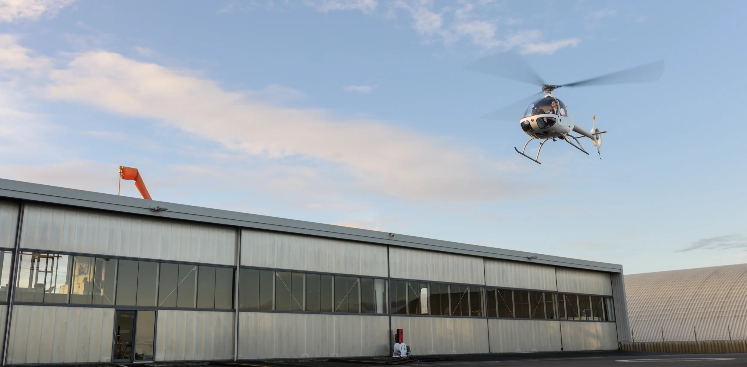
Our Recon team includes highly experienced CAA Part 102 certified UAV pilots, delivering safe, compliant and reliable aerial surveying services.
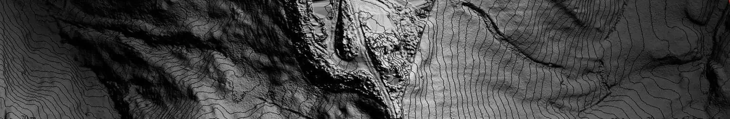
Aerial mapping is the process of collecting geospatial data from the air to create accurate maps and 3D models of the Earth’s surface. It uses aerial photographs and remote sensing technologies to capture detailed information about land, terrain and structures.
-
A major advantage of aerial mapping is its ability to quickly, safely and accurately capture large areas of land. Making it a valuable and cost-saving tool for monitoring land use, as well as for conducting surveys and assessments in remote or hard-to-reach areas.
It is commonly used for urban planning, land management, environmental monitoring, infrastructure projects and disaster response.
-
Step into the future with our digital twins – virtual replicas of physical environments. By merging spatial data with advanced modelling techniques we create dynamic digital twins that mirror reality with precision. From monitoring infrastructure performance to optimising operations, our digital twins provide a transformative approach to visualisation, simulation, and planning.
-
No matter your industry or sector, we have the expertise to deliver customised spatial data solutions that drive results. Whether you're in real estate development, transportation, energy, or public safety, our team understands your unique challenges and objectives. We work closely with you to design solutions that streamline workflows, improve efficiency, and enhance decision-making.
Our Aerial Mapping Expertise
We are a highly experienced team led by Jeremy, who brings 25 years of expertise in the spatial industry, including surveying, LiDAR and aerial mapping. Collectively, our team has over 50 years of experience in the spatial industry, and we have delivered over 900 UAV jobs. We capture high-resolution data of towns, cities, landscapes and infrastructure. We recently completed a 3D mapping project for Waikato District Council capturing all their townships.
Whether you're in urban planning, agriculture, construction, environmental management, or any other industry sector, our aerial mapping service solutions empower you to visualise, analyse and strategise with confidence.
We hold a SiteWise Gold Certificate for health and Safety.
Call us now to see how we can help.
Covering New Zealand
Located in the North Island and serving clients across the nation, our team is well-versed in the distinct challenges and opportunities inherent in New Zealand's varied landscapes and communities. Our goal is to assist in your decision-making process while honouring the cultural and environmental values of Aotearoa.
Our Aerial Mapping Workflow
What Happens During Project Planning for an Aerial Mapping Survey?
Define accuracy requirements, outputs, coverage area and regulatory constraints.
How Does Flight Planning Work in Aerial Mapping?
Design flight paths, altitude, overlap and sensor settings to meet accuracy targets.
What Are Ground Control Points (GCPs) in Surveying? (if required)
Establish and survey GCPs to ensure geospatial accuracy and validation.
How Is Aerial Mapping Data Captured?
Fly the area using drones or crewed aircraft, collecting imagery or LiDAR data.
How Is Aerial Mapping Data Processed?
Process raw data into georeferenced outputs such as orthomosaic, point clouds and surface models.
How Is Aerial Mapping Accuracy Verified?
Verify accuracy against control points and project specifications.
What Deliverables Are Provided After an Aerial Mapping Survey?
Deliver final datasets and reports in formats ready for CAD, GIS or engineering use.
-
Aerial mapping services New Zealand involves mounting a camera or sensor on an aircraft or drone to capture high-resolution images and data from a bird’s-eye view. This information is then processed using specialised software to produce accurate maps, 3D models and other geospatial products.
Using a specialised mapping camera system, we capture both vertical (nadir) and oblique imagery at the same time. This allows us to generate 2D maps and detailed 3d models from a single flight. The approach provides a comprehensive view of built-up areas and natural environments, delivering highly detailed, photo-realistic data.
-
Fast & efficient – Large areas can be captured in a fraction of the time compared to ground surveys.
High accuracy – Modern drones and LiDAR systems deliver survey-grade data.
Cost-effective – Reduced field time means lower project costs.
Safe access – Ideal for hazardous, remote or hard-to-reach sites.
Rich data outputs – Generate orthophotos, point clouds, contours, DSM/DTMs and 3D models.
Repeatable & scalable – Easy to re-fly sites for progress tracking or change detection.
What Deliverables Will You Receive?
-
Virtual replicas of physical environments, assets, or processes, created through the integration of spatial data and advanced modelling techniques.
-
High-resolution, geometrically corrected aerial images that provide an accurate representation of the Earth's surface.
-
Dense collections of colourised 3D points representing the surface of objects or terrain, ideal for detailed analysis and visualisation.
-
Detailed digital representations of the Earth's surface, capturing elevation data and terrain characteristics. Surfaces are commonly delivered as TIN (triangular irregular network), grid DTM (or DEM) and contours.
-
Geospatial data represented by points, lines, and polygons, providing precise mapping information for analysis and modelling.
Industries
-
Agriculture & Forestry
High-resolution RGB orthophotography essential for asset management and harvest planning, alongside LiDAR-derived Digital Terrain Models (DTMs) crucial for detailed harvest road and haul planning.
-
Land Development
Ortho and LiDAR-derived ground contours for design and pre-earthworks calculations, enabling precise planning. Additionally, 3D visualisations aid in project conceptualisation, while architectural concepts enhance stakeholder engagement. Oblique photos are provided for dynamic marketing, and features like kerbs and road crown are digitised for detailed mapping.
-
Local Government
Project-specific flights for land development, infrastructure, and asset surveys, alongside GIS aerial photography updates. Our expertise extends to Digital Surface Models (DSM) for development planning and line-of-sight analysis. We specialize in discreet data gathering for environmental court cases and sensitive coastal developments. Furthermore, our services encompass river and stream monitoring, as well as coastal mapping for erosion, cliff-face analysis, flood modelling, and tsunami modelling, ensuring comprehensive environmental management support.
-
Mining
DSM and contour mapping services tailored for precise volume calculations of mine, quarry, and stockpile operations. Our solutions provide accurate snapshots in time, with data turnaround within 24-48 hours of flight. Compared to ground surveying, our aerial surveys offer safer and faster slope face assessments. Additionally, our approach is more cost-effective than field surveys and offers higher accuracy than large format aerial photography.
-
Power and Utilities
Aerial surveys using drone LiDAR technology for power conductor, asset, and pipeline monitoring. Our services include generating Digital Surface Models (DSM) and orthophotography for hazard and ground movement monitoring. Additionally, we provide orthophotography tailored for property asset management and deliver ground, vegetation, and pole height data essential for thermal upgrade and re-tensioning design. Moreover, we excel in mapping vegetation and modeling growth through repeat surveys, as well as conducting precise as-built surveys to ensure accurate project documentation.
-
Transport
Orthophotography via drone surveys for road and rail route planning and analysis. Our LiDAR-derived Digital Terrain Models (DTM) provide comprehensive design insights, supplementing ground surveys for detailed design accuracy. Regular flights during construction aid progress monitoring, while DTMs facilitate month-end earthworks calculations.
Case Studies
-
New Zealand Steel Aerial Mapping
NZ Steel uses Recon UAV mapping to regularly measure stockpile volumes at its Waikato North Head mine, capturing data quickly and safely without putting surveyors in hazardous areas.
Measurable Outcomes:
~15 minutes typical UAV flight time per survey
<3% volume measurement error (often better)
0 operational shutdowns required during data capture
Improved safety by eliminating the need for survey staff in active mining zones
-

LiDAR Mapping for Kiwirail
Recon used UAV surveying along a 2–3 km section of KiwiRail’s Midland Line to support University of Canterbury research into geotechnical risk, providing fast, cost-effective data on hazards like erosion and debris flow without disrupting rail operations.
Measurable Outcomes:
2–3 km rail corridor surveyed along the Midland Line
Faster data turnaround compared with traditional ground surveys
Lower survey costs for remote or difficult-access locations
No disruption to active rail operations during data capture
FAQ’s
How accurate are drone surveys compared to traditional surveying?
Drone mapping surveys can achieve centimetre-level accuracy, comparable to traditional surveying when using GCPs or RTK/PPK systems. They are faster and more efficient for mapping large areas. Recon provides UAV mapping NZ services, and aerial surveys.
Do you need a license to conduct an aerial survey?
For many surveys no, however, if you’re operating over private properties or road parcels, for example, then often yes a license is required. In New Zealand for these types of surveys pilots must be NZ CAA Part 102 certified and follow all aviation safety regulations.
What areas of New Zealand do you cover?
Recon is in Auckland but operates nationwide.
How long does an aerial mapping project take?
The duration of an aerial mapping project depends on the size, complexity and deliverables required, but most projects are completed within a few days to several weeks.
What is the difference between aerial mapping and drone mapping?
Aerial mapping is the broader process of capturing and analysing geospatial data from above using platforms such as drones, crewed aircraft or helicopters, while drone mapping is a specific type of aerial mapping that uses unmanned aerial vehicles (UAVs) to collect the data.
How is a digital twin created in aerial mapping surveying?
Digital twins in aerial mapping are created by collecting high-resolution aerial imagery using drones, aircraft or satellites equipped with advanced sensors. The collected data is then processed and analysed to generate a 3d site model or representation of the surveyed area.
Can digital twins be updated with new data?
Yes, digital twins can be updated with new data to reflect changes in the surveyed area over time. This allows for real-time monitoring of dynamic conditions, such as construction progress, vegetation growth, or natural disasters.
Talk to our team today to discover how our aerial mapping services can support your project. We are happy to quote on work.