
Drone Mapping
Aerial drone mapping performed using unmanned aerial vehicles (UAVs), also known as drones.
One of the major advantages of aerial UAV drone mapping survey is its ability to quickly and accurately capture large areas of land, providing a range of data and maps including topographic maps, orthophotos, and digital elevation models. This makes it a valuable tool for monitoring land use and changes over time, as well as for conducting surveys and assessments in remote or hard-to-reach areas.

-
Often survey controlled to achieve high accuracy orthophotography, raw photos are ‘stitched’ together to create a seamless, spatially accurate image for import into your CAD or GIS software.
-
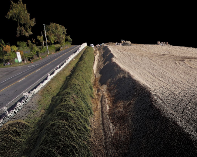
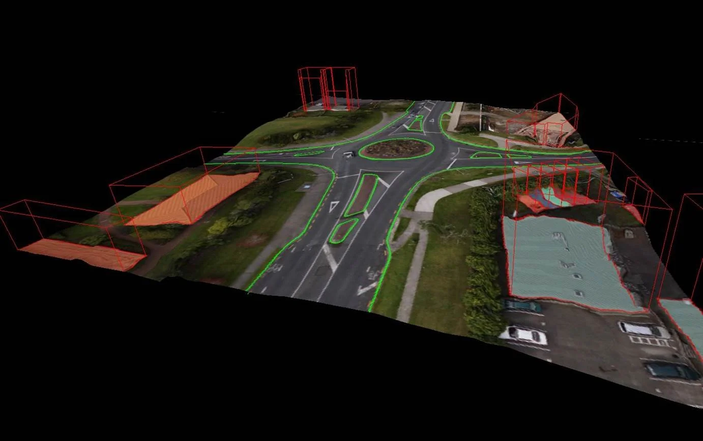
Using vertical only or a combination of vertical and oblique images, Recon can build highly visual 3D meshes for use in planning, design or many other applications.
-
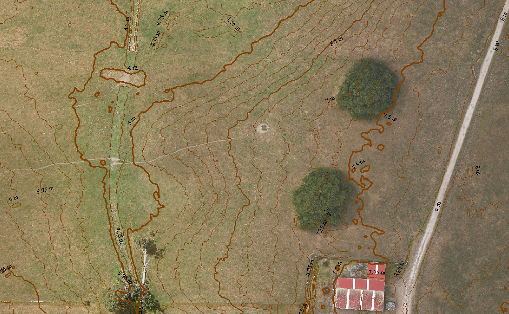
The photogrammetric process allows us to generate 3-dimensional surfaces including mapping the ground and generating a TIN surface or contours.
-
Photogrammetry enables vectorisation of 2D and 3D features, down to accuracies of sub 10mm in some circumstances. These features can be exported in any common CAD or GIS format.
-
After the creation of orthophotography and 2D or 3D features further GIS analysis can be performed.
-
Recon operates a variety of cameras for different applications. Flights can be pre-programmed to follow waypoints or capture in a grid format, for example when capturing a large roof area or building facade.
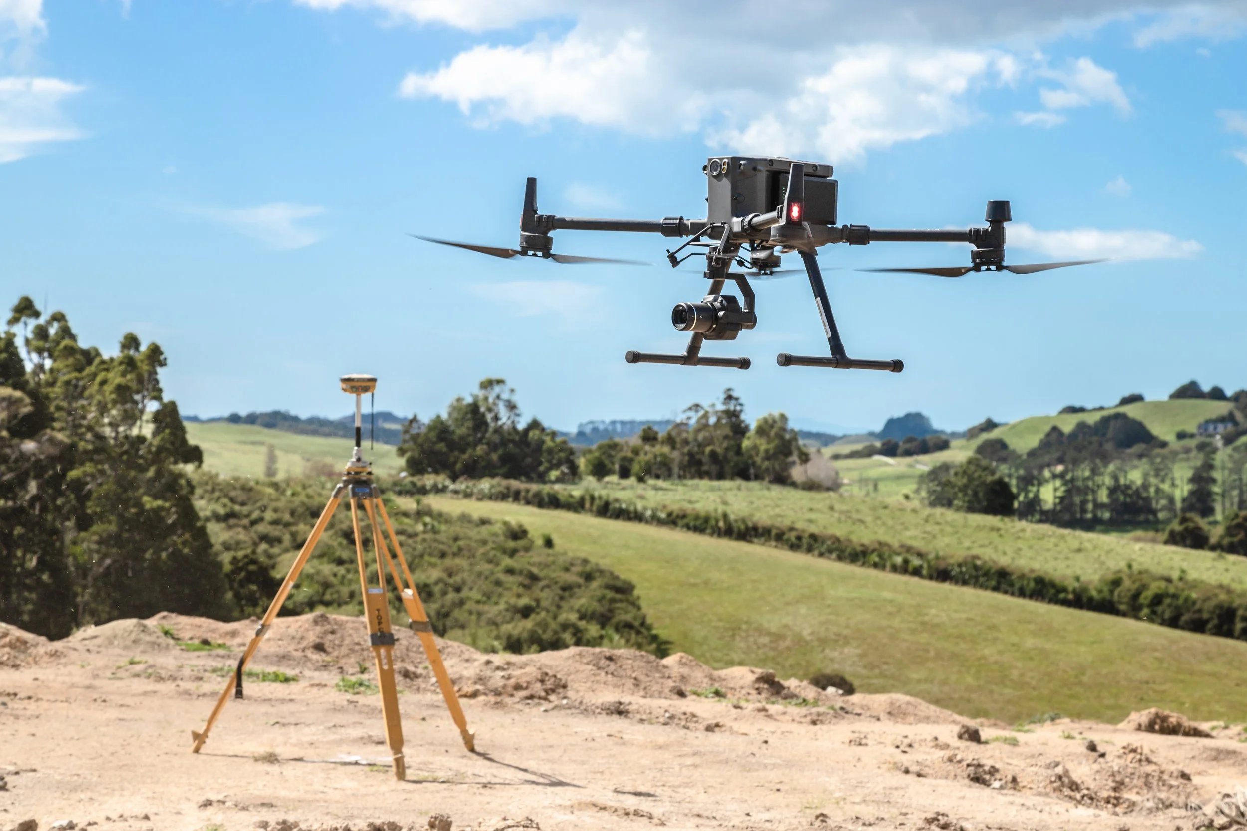
A camera or a sensor is mounted on the aircraft or drone, which takes high-resolution images or captures other data from a bird's-eye view.
The images or data are then processed using specialised software to create maps, 3D models, and other geospatial products.
Aerial drone UAV land survey is used in a variety of applications, including urban planning, land management, environmental monitoring, and infrastructure design. It is also used for disaster response, as it allows responders to quickly assess damage and plan recovery efforts.
Industries
-
Agriculture & Forestry
High resolution RGB orthophotography for asset management and harvest planning
LiDAR DTM for harvest road and haul planning
-
Land Development
Ortho and LiDAR-derived ground contours for design and pre-earthworks calculations
3D visualisation from reality modelling
Architect concepts for demonstration purposes
Oblique photos for marketing purposes
Digitising of features such as kerbs, road crown and break-lines
-
Local Government
Project specific flights covering new land development, infrastructure and assets
GIS aerial photography updates
DSM for development planning, line-of-site analysis
Unobtrusive data gathering for environment court cases, illegal earthworks, sensitive coastal developments etc
River and stream monitoring
Coastal mapping, erosion monitoring, cliff-face mapping flood modelling and tsunami modelling
-
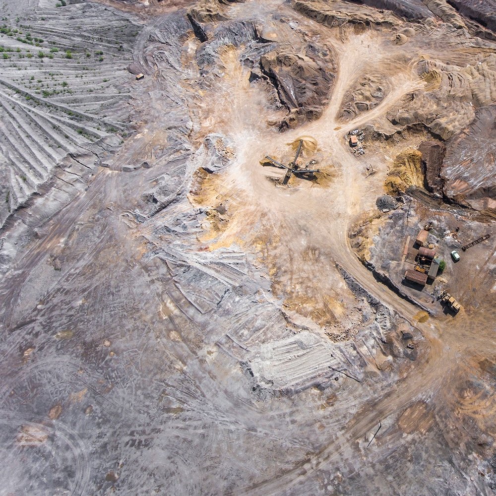
Mining
DSM/contours for mine, quarry and stockpile volume calculations for mine/quarry stockpiles
Accurate snapshot in time
Data turned around within 24-48 hours of flight
Safer and faster than ground surveying slope faces
More cost-effective than field survey and more accurate than large format aerial photography
-
Power and Utilities
Power conductor, assets and pipeline aerial survey via drone LiDAR
DSM and ortho for monitoring hazards or ground movement
Orthophotography for property asset management
Ground, vegetation and pole height data for thermal upgrade/re-tensioning design
Mapping vegetation, modelling growth through repeat surveys
As-built surveys
-
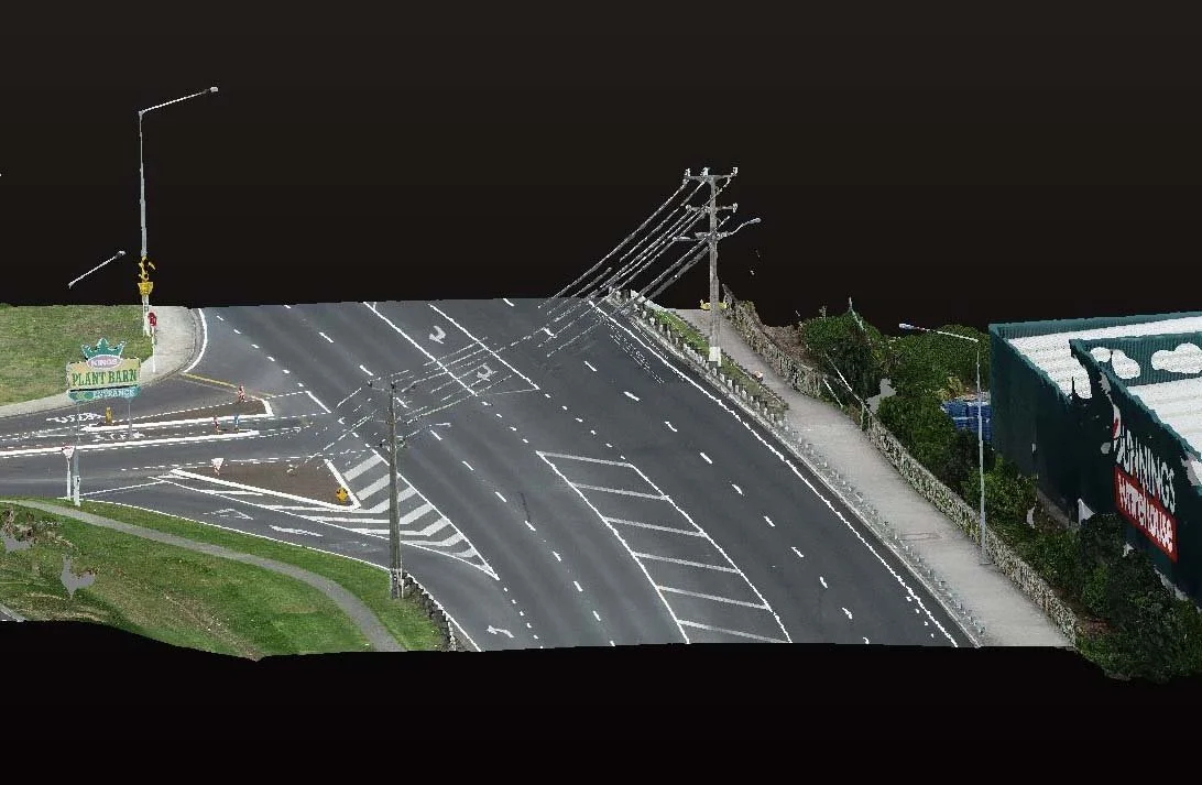
Transport
High resolution orthophotography via drone survey for planning and analysis of proposed road and rail routes
LiDAR-derived DTM of wider corridor, enabling a more comprehensive design
Supplements ground survey and is accurate enough for detailed design
Regular flights during construction assist with progress monitoring
DTM for month-end earthworks calculations
Case Studies
-
NZ Steel UAV - Taking Stock
Recon’s UAV consultancy service provides New Zealand Steel with a safe and fast way of acquiring stockpile volume data.
-

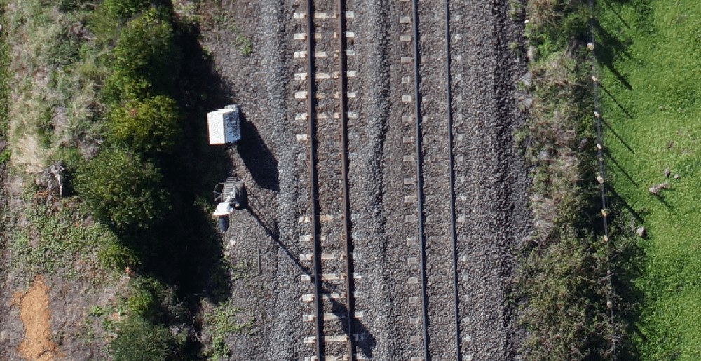
UAV Survey – KIWIRAIL'S Key Link
As a supervisor on University of Canterbury masters student Julia Watson’s MSc thesis, Richard recently got to explore the benefits of this rapidly developing technology when a UAV was deployed by Recon’s consultative team as part of the project.
Darren Lloyd - Thornley & Associates
“We have engaged Recon to undertake Aerial Surveys on multiple occasions and Jeremy and his team provide quality imagery and Lidar data. I would thoroughly recommend using Recon for Aerial surveying services.”
FAQs
What are the benefits of aerial drone UAV mapping?
Drone mapping is efficient, accurate, and safe, and can provide high-resolution imagery and 3D models. It can be used in hard-to-reach areas, making it a flexible and versatile tool. Drone mapping can reduce the environmental impact of mapping activities and aid in better decision-making for planning, design, and management activities. In agriculture, it can be used to monitor crops and soil health, while in emergency response, it can provide real-time imagery and mapping for search and rescue efforts and damage assessment.
When is aerial survey drone mapping important?
It is important where accurate and detailed information about a large area of land or infrastructure is needed. Aerial mapping can provide high-resolution imagery, 3D models, and topographic data that are essential in a range of industries and applications. For example, in surveying and mapping, aerial mapping can create detailed maps and topographic data that aid in land-use planning, urban design, and infrastructure development. In environmental monitoring, aerial mapping can provide data on land use, vegetation cover, and water quality, aiding in conservation and natural resource management efforts. In agriculture, aerial mapping can monitor crop health, identify areas of potential stress, and improve yield. In emergency management, aerial mapping can provide real-time data on natural disasters, aiding in response and management efforts. Aerial mapping is important in situations where ground-based surveys and inspections are impractical, inefficient, or unsafe, and where accurate, detailed, and up-to-date information is needed to make informed decisions.
What does aerial UAV drone survey mapping services include?
In surveying, it encompass a range of activities, including flight planning, data collection, and data processing. This includes photogrammetry, LiDAR, orthophotos, topography, GIS, point cloud, GCPs, RTK, accuracy, and deliverables. Photogrammetry involves making measurements from photographs, while LiDAR uses lasers to generate precise elevation data. Orthophotos are high-resolution, geometrically corrected aerial photographs used as a base map for surveying, and topography involves the study and mapping of the earth's surface. GIS is a tool used to manage and analyze spatial data, while point clouds are collections of data points in a three-dimensional coordinate system. GCPs are used to georeference and calibrate aerial images, while RTK is a high-precision GPS technique used for surveying and mapping. Accuracy is a critical factor in surveying and mapping, and deliverables may include orthophotos, 3D models, point clouds, and other data products.
What are the differences between traditional surveying and aerial drone mapping nz?
One key difference between the two is the scale and scope of the data collection. Traditional surveying is typically done on a small scale, such as a single building or a small plot of land. This method involves taking precise measurements and angles using equipment such as total stations and GPS receivers. Aerial mapping, on the other hand, involves collecting data over a large area from an aerial perspective. This method utilises drones or planes equipped with cameras, LiDAR sensors, and GPS to capture detailed aerial images and 3D models.
Another important difference is the speed and efficiency of data collection. Traditional surveying is a time-consuming process that requires manual measurements and data collection, whereas aerial mapping can cover large areas quickly and efficiently. Aerial mapping can also capture data from inaccessible or hazardous areas that would be difficult or dangerous to survey on foot.
Both traditional surveying and aerial mapping have their advantages and disadvantages, and the choice of method depends on the specific needs and constraints of the project.
Contact Us For Drone Survey Services
Location
Auckland & NZ Wide
Phone
0800 732 669
Email
info@recon.nz
Aerial Mapping Surveying
Project-focused to meet the diverse needs of industries including agriculture, forestry, land development, local government, mining, power, utilities, and transport. Our comprehensive solutions encompass high-resolution orthophotos, LiDAR-derived point clouds, and digital surface models facilitating accurate digital twins of your assets using an aircraft.