
Leveraging 3D Mapped Cities for Urban and Transport Planning
Facing rapid urbanisation and evolving needs, cities around the world encounter challenges in effectively managing its urban landscape, infrastructure and natural resources. Traditional planning methods struggle to keep pace with such a dynamic environment, leading to inefficiencies in decision-making and service provision. In response to these challenges 3D mapping technology provides a multi-layered solution. By mapping the land, vegetation and structures in three dimensions it creates a comprehensive digital replica of the urban landscape.
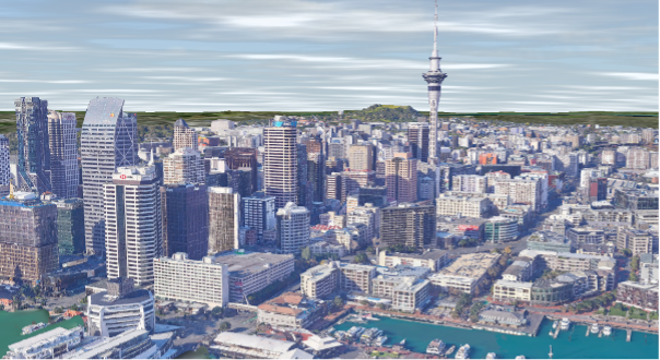
Photo-realistic and accurate 3D colour meshes provide a base for central and local government organisations, together with their consultants, to visualise design proposals such as developments, infrastructure projects and zoning changes in much more detail. By leveraging the 3D mapping, innovative tools and fostering collaborative partnerships, the stakeholders are not only able to address existing challenges but also lay the foundation for a more sustainable and resilient future.
There are in fact many applications, during emergencies a 3D mapped city provides invaluable insights for emergency responders, enabling them to swiftly identify evacuation routes, assess risks and coordinate rescue operations. By optimising infrastructure management and disaster response mechanisms, the city can bolster its resilience and responsiveness.
Environmentalists and policymakers can utilise the 3D model to monitor changes in land use, vegetation cover, and wildlife habitats, informing conservation strategies and land management policies aimed at preserving the city's natural heritage. Councillors gain deeper insights into urban dynamics, enabling them to make informed decisions that align with the city's long-term vision.
The adoption of 3D mapped cities yields tangible benefits for the city and its residents. Through innovative public engagement initiatives, residents can feel empowered to contribute to the city's development, fostering a sense of ownership and community pride.
Through interactive platforms and virtual tours residents are empowered to explore the city's proposed developments, offer feedback and actively participate in shaping the future of their community, fostering a culture of transparency and collaboration.
By integrating 3D mapping data with other spatial datasets such as demographic information, land use patterns, and transportation networks, planners can conduct sophisticated analyses. This includes assessing accessibility, identifying areas of high population density, and evaluating the suitability of proposed developments. 3D GIS software facilitates scenario planning by enabling planners to explore alternative development options and evaluate their potential outcomes. Through advanced analytics and visualisation tools, planners can assess trade-offs, identify optimal solutions and make data-driven decisions that align with community goals and priorities.
3D mapping software allows planners to monitor the performance of urban systems and infrastructure over time. By tracking key indicators such as traffic flow, air quality and energy consumption, planners can identify trends, evaluate the effectiveness of interventions and adapt strategies to meet changing needs and conditions.
Enquiries to Recon can be made through freephone 0800 732 669 or email info@recon.nz