

Skyline Software
Recon is the New Zealand reseller of Skyline Software.
Founded in 1997, Skyline Software Systems, Inc. is a leading provider of 3D earth visualisation software and services. Skyline offers a comprehensive platform of applications, tools, and services that enable the creation and dissemination of interactive, photo-realistic 3D environments. Skyline products are production proven in both the Defence and Commercial markets. A “best of breed” set of tools that remain focused on customer needs including flexibility, efficiency, and robustness.
Leaders in 3D Geospatial Visualisation Since 1997
-

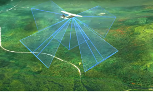
PhotoMesh
PhotoMesh automates the generation of high-resolution, textured, 3D mesh models from standard 2D images. This breakthrough application combines unlimited scalability with superior precision to produce consistent, accurate 3D models that enhance the realism of any 3D visualisation.
-
TerraBuilder
TerraBuilder is a 3D terrain database creator featuring professional-grade tools for manipulating and merging aerial photos, satellite images, and digital elevation models of different sizes and resolutions. The resulting photo-realistic, geographically accurate terrain database can be made available to local TerraExplorer clients or published to SkylineGlobe Server.
-

SkylineGlobe Server
SkylineGlobe Server (SGS) is a private cloud solution that provides a comprehensive set of web services for publishing, storing, managing and streaming 3D geospatial data. Skyline provides a secure environment and interface that allows you the ultimate flexibility for your geospatial data storage and streaming needs. Included in our SGS package is TerraExplorer, giving you the option of using Skyline's 3D geospatial visualisation tools to optimise your data.
-
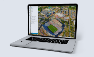
TerraExplorer
The TerraExplorer family of products comprises a range of 3D GIS clients for viewing, querying, analysing and presenting geospatial data in a high resolution 3D environment. Using Skyline’s cutting-edge TerraExplorer application, stunningly realistic 3D visualisations can be created and then shared with web, desktop, and mobile users. The wide range of powerful analysis tools available from all TerraExplorer applications allows users to extract vital intelligence from geospatial data.